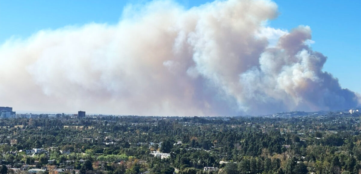
State Modifies Fire Hazard Severity Zones in Beverly Hills

The California Department of Forestry and Fire Protection (Cal Fire) has released revised maps identifying fire hazard severity zones throughout the state, and the designations of certain areas in Beverly Hills have changed. 

The new maps—which label regions in the state as moderate, high or very high fire hazard severity zones—designate approximately 260 additional acres of Beverly Hills as very high, according to Jim McDougald, Assistant Deputy Director, Cal Fire Community Wildfire Planning and Risk Reduction. 

Those new areas, said Trevor Richmond, Beverly Hills Assistant Fire Chief – Fire Marshal, are predominantly south of Sunset Boulevard. 

“Prior to the new map coming out, the very high zone was north of Sunset,” Richmond said. “So, you’ll look at the new map and you’ll see that the [very high area] is actually extended.” 

In most of Beverly Hills, the new border of very high fire hazard severity zones runs, roughly, east to west between Lomitas and Elevado Avenues. On the old map, that border ran roughly along Sunset Boulevard. 

To determine what zone their home falls in, if any, residents are advised to type their address into the official map on the Cal Fire website.

Richmond notes that the city has been working to get granular with the borders as some Beverly Hills lots appeared to be “cut in half,” he said, by the boundaries between very high and high zones issued by the state. 

Richmond is also collaborating with a city staff member who works with geographic information systems to examine lots one at a time and determine each property’s correct zone. 

“We’ve gone through all the lots that are half in, half out, and we’ve typed in those addresses [and] readjusted the maps to reflect more accurately what zone each lot is in,” he said. “We’ve done a lot of work to make it really clear.”

The city plans to distribute a flyer within the next several weeks that shows those designations, as well as post the information on their website. 

The new maps were created by Cal Fire using updated systems. Those systems allow experts to more accurately account for wind patterns, including speed and direction, that are likely to blow embers from high vegetation areas into urban or non-wildland areas. The new borders in Beverly Hills reflect that increased predicting ability.

“What the model does now that it didn’t do before is mapping, basically, where the embers from that adjacent vegetation are going to land,” McDougald said. 

Work on the new maps has been ongoing since 2022. It came on the heels of a state bill that required Cal Fire to create fire hazard severity zone maps for Local Responsibility Areas (LRA), where the local government is responsible for wildfire protection, in addition to State Responsibility Areas (SRA), where the state is financially responsible for wildland fire protection and prevention.

“We did the SRA adoption first,” McDougald said. “The SRA was finally adopted and went into effect April 1, 2024, and then we started on the Local Responsibility Area.”

Individuals whose home or property is located in very high severity zones are required to comply with laws that govern so-called defensible space, which refers to maintenance regulations for the area around the structure. 

Those regulations include reducing intense fuel within 5 feet of the structure and managing vegetation that exists up to 100 feet from the structure. 

Richmond said the Beverly Hills Fire Department (BHFD) plans to conduct an ongoing public education campaign to help residents understand the new maps and requirements, particularly homeowners who are newly affected by the very high fire hazard severity zone. That might mean a lighter touch with code enforcement as more information is provided to residents. 

“Over the next couple years, it’ll be a public education, probably, versus a code enforcement issue,” he said. “After a couple years … we’ll apply the code and begin the code enforcement.”

Beverly Hills also recently released an updated Local Hazard Mitigation Plan (LHMP). The plan will allow residents to be more prepared to face natural disasters, including wildfires. 

According to a statement from the city, members of the community are invited to respond to the plan between April 21 and May 5. In order to qualify for grants from the Federal Emergency Management Agency and California Governor’s Office of Emergency Services, the plan must be adopted as a prerequisite. 

Residents interested in looking up their home to see where it falls on the new Cal Fire maps can use this link: https://osfm.fire.ca.gov/what-we-do/community-wildfire-preparedness-and-mitigation/fire-hazard-severity-zones.

Residents interested in viewing and responding to the LHMP may visit: https://www.beverlyhills.org/1447/Hazard-Mitigation-Plan-Update or email comments to hazardmitigation@beverlyhills.org.